Handle distorted images and setup dataset
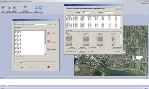
OPK StartKit is the Menci module to handle distorted images (with K1, K2, K3, P1, P2 values) into OPK suite. Moreover it includes standard procedures to preprocess your data and make it suitable for next steps.
The simple and intuitive interface allows the user an immediate interaction with the features offered. The workflow pass through edit camera passport, generation of undistort images, camera position and angles evaluation.
StartKit transforms original raw data in order to get final GIS data.
OK StartKit is a part of OPK photogrammetry software suite, including several cartography software.
Main features
- High Performance
- Blocks of thousands of images
- Modular solution
- Accurate procedures
- User friendly (minimal interface)
- Openness (no proprietary format)
- Self-contained (no other software requested)
- Customizable (we can respond and provide solutions to custom requests)
- Available for Windows Vista, 7 and 8 (32 / 64 bit)
Aerial Mapping
MakeUp

Software per GIS e Cartografia La suite OPK è un set di software per GIS e cartografia aerea dedicati al processamento di immagini large format acquisite con camere aeree o satelliti...
Maggiori InformazioniBlend

Software per GIS e Cartografia La suite OPK è un set di software per GIS e cartografia aerea dedicati al processamento di immagini large format acquisite con camere aeree o satelliti...
Maggiori InformazioniSurf

Software per GIS e Cartografia La suite OPK è un set di software per GIS e cartografia aerea dedicati al processamento di immagini large format acquisite con camere aeree o satelliti...
Maggiori InformazioniWarp

Software per GIS e Cartografia La suite OPK è un set di software per GIS e cartografia aerea dedicati al processamento di immagini large format acquisite con camere aeree o satelliti...
Maggiori InformazioniBundle

Software per GIS e Cartografia La suite OPK è un set di software per GIS e cartografia aerea dedicati al processamento di immagini large format acquisite con camere aeree o satelliti...
Maggiori InformazioniStartKit

Software per GIS e Cartografia La suite OPK è un set di software per GIS e cartografia aerea dedicati al processamento di immagini large format acquisite con camere aeree o satelliti...
Maggiori InformazioniSoftware fotogrammetria
OPK SAT, Software per immagini da Satell…

A Multi-faceted approach Partner removes the hassle and confusion that comes from managing your tax burden effectively. Our tax services range from discrete, one-time advice to complete management and everywhere in...
Maggiori InformazioniOPK, Software per immagini da Aereo (2)

Software per GIS e Cartografia La suite OPK è un set di software per GIS e cartografia aerea dedicati al processamento di immagini large format acquisite con camere aeree o satelliti...
Maggiori InformazioniAPS - Photogrammetry Software

La suite OPK è un set di software per GIS e cartografia aerea dedicati al processamento di immagini large format acquisite con camere aeree o satelliti. OPK garantisce alte prestazioni...
Maggiori Informazioni
")